About The Project
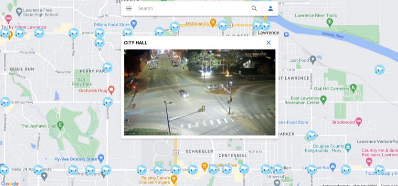
Mapsy is an interactive web app that analyzes CCTV imagery and weather data to determine realtime road conditions in Lawrence, KS.
Built With
Getting Started
Prerequisites
Make sure you have Node.js installed: https://nodejs.org/
Installation
- Create a new firebase project in order to get your API keys: https://firebase.google.com/
- Generate a Google Maps API Key: https://cloud.google.com/
- Clone the repo in terminal:
git clone https://github.com/codyduong/HackKU2022.git
- In the main folder HACKKU2022, create a .env file and paste your API keys in there. Template below:
REACT_APP_GOOGLE_MAPS_API_KEY=
REACT_APP_apiKey=
REACT_APP_authDomain=
REACT_APP_projectId=
REACT_APP_storageBucket=
REACT_APP_messagingSenderId=
REACT_APP_appId=
REACT_APP_measurementId=
- In terminal, run Yarn and use it to build the application:
yarn
yarn build
Usage
Mapsy makes it easier to view the current status of road conditions, especially during periods of inclement weather. By viewing realtime CCTV images at major intersections, users may determine whether or not the road conditions are safe for travel.
Roadmap
- Integrate Material UI & Stylized Components
- Add Google Maps API Integration
- Add current location zoom to Google Map, fully integrate Searchbar
See the open issues for a full list of proposed features (and known issues).
Contributing
Contributions are what make the open source community such an amazing place to learn, inspire, and create. Any contributions you make are greatly appreciated.
If you have a suggestion that would make this better, please fork the repo and create a pull request. You can also simply open an issue with the tag “enhancement”. Don’t forget to give the project a star! Thanks again!
- Fork the Project
- Create your Feature Branch (
git checkout -b feature/AmazingFeature) - Commit your Changes (
git commit -m 'Add some AmazingFeature') - Push to the Branch (
git push origin feature/AmazingFeature) - Open a Pull Request
License
Distributed under the MIT License.


