Starlink

Project Description
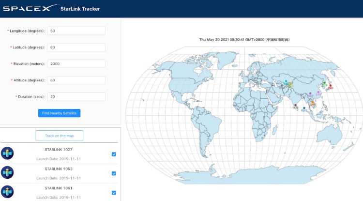
Ready for a space adventure? Starlink is a React.js project to track satellites in real-time based on geo-location. Users can enter parameters including longtitude and latitude to find all matched satellites, and then select one or a few satellites to view their animated trajectory on a world map for a custom duration. The real-time satellite tracking functionality is enabled by N2YO.com.
Technical Details
A lightweight frontend project based on React.js, Starlink uses Ant Design for user-friendly UI components and D3 for dynamic satellite visualization. It also uses the Axios library to make AJAX requests and create-react-app-buildpack to deal with CORS issues. It is now deployed on Heroku and served via Nginx for better stability.
The app is bootstrapped using create-react-app boilerplate. The React component layout diagram is illustrated as below:

How to Use

- Visit the Starlink website, enter all the parameter settings on the upper-left panel and click “Find Nearby Satellite”. If you have no clue about the settings, feel free to use the example settings in the table below.
| Parameter | Unit | Range | Example |
|---|---|---|---|
| Longtitude | degree | -180 – 180 | 50 |
| Latitude | degree | -90 – 90 | 60 |
| Elevation | meter | -413 – 8850 | 2000 |
| Altitude | degree | 0 – 90 | 80 |
| Duration | second | 0 – 90 | 20 |
- Select the satellites you want to see on the bottom-left panel, click “Track on the map” and wait for the animation to load. Notice that “no data” will appear if there are no satellite on your specified geo-location, which means you need to go back and adjust your satellite settings.
- View the selected satellite paths on the world map, and be awed!
For Developers
- To develop locally, download the project from my GitHub, cd into the folder and run
npm install. You can later runnpm startto start the app on the default localhost:3000 port andnpm run buildto build the project for production.
Handy References
Rui Zhang
Jan 11, 2022